CadTools,
free 3D
and
surface
utility for
BricsCAD
Design your civil work in
real 3D with this handy tool!
Latest update:
2026-03-27
Build
770
CadTools (ToolBox) is
developed for Civil Engineers using CAD. There are a number of great
software on the market supporting the design process of roads, rails
etc. For minor design work CadTools can be very useful,
it contains more than
50 commands mostly in real 3D to support
your work.
By combining separate commands through the work process you can achieve
almost anything you want. When I developed the
commands I certainly had some situations in mind but every command can
be used in a variety of situations not only
in civil work design.
With CadTools
you can create your own surface models based on objects in the drawing
or import triangles from DWG (other civil software). You can create
profiles and cross-sections of multiple surfaces, calculate volumes and
plot contours.
It's easy and fun creating real 3D models
with CadTools commands, some of these commands can only
be found in software that you have to pay money for.
I've
worked as a civil designer at some of Sweden's
leading consulting companies.
My main
tool for civil design have been Bentley InRoads/RailTrack, one of the best software I've
used. Sometimes you need something less complicated so I started developing CadTools
for AutoCAD while traveling to work by train.
After more than five years and
thousands of hours of developing this software now is a powerful tool way beyond my
first intentions. Honestly I can't be without it,
hope
you will feel the same.
CadTools is an out of process software and supports AutoCAD versions:
2001- (vanilla and
verticals i.e. Civil 3D). It also supports ZWCAD+ (2014-2015 and 2018-)
and BricsCAD
|
Major Commands
in CadTools are listed below. CadTools has a complete
helpfile with images of command results.
|
Text
Insert or remove characters to single line text.
Align
text to UCS and scale it.
Align Text to Left.
Send selected text to Excel
Line
Aligned Text
Capitalize/Uncapitalize
text
Lines
Area calculation of polylines based on color or
layer. Results can be exported to Excel
Export polyline coordinates to Excel
Length calculate of polylines based on color
or layer. Results can be exported to Excel
Reverse polyline
Point section and offset from polyline
Draw slopemarks from polylines
Offset 3DPolylines
Create cylinders (pipes) from polylines/lines.
Profile 3DPolyline
Create road signs and markings
Level out 3Dpolyline
Transverse 3D lines between 3D Polylines (3D Slope signs)
Join
3D Polylines
Draw
Slope Arrows for 3Dpolylines (Ditch bottom slope direction)
Stationing Polyline
Line
Aligned Text
Edit
Polyline Elevation and slope
(In table)
Create 3D alignment from plan and profile
Best fit, 3D-polyline regression.
Simplify
command for 3D-polylines
Set polyline elevation by nearest text, fixes contours with no elevation
but text!
Lines/Polylines to EPANET
INP-file
Layers
All layers on
All layers off but selected
All layers off but current
Layer off by object
Xref layer freeze by single object
Move to layer by object
Set current layer by object
Delete layer
Draw
Draw polylines, circles and blocks from
coordinates. Paste from Excel to CadTools
|
|
Surface
Generate
longitudinal features (ditch bottom, surface interception) with cut/fill
tick marks.
Import Triangulated Surface from Graphic (from other software)
Triangle Volume and color cut/fill areas in plan.
Triangulate objects (create surface models)
Drape
surface with objects and lines
Pick and annotate elevation from surface
Create wireframe surface
Cut & Fill areas in cross-sections
Create Surface Profiles
Create Surface Cross Section
View Surface Slope and Direction
View
Perimeter for flat
(or any slope interval)
Surface Areas
Pick
and annotate Slope vector from surface
Constrained triangulation (breaklines)
Surface Contours
Trickle, traces the path of a drop of
water down a selected surface.
Volume
by Elevation, triangle volumes at intervals
Trickle All, evaluate surface water paths.
Convert
Convert 3DPolylines to 2Dpolylines
Convert 3DFaces to 3Dpolylines
Convert arc to 3Dpolyline
Create coordinate grid
Place sloped text
Convert Circle to 3Dpolyline
Xref
Open Xref by Object
Detach Xref by Object
Save/Load Xref-settings to/from file
Block
Edit block
attribute text
Annotate block elevation
Drainage network evaluation, evaluation of block
(manholes) and Lines (pipes). Result in Excel
Export block information to Excel (coordinates, attribute values)
Hatch
Export Hatch area to Excel
Miscellaneous
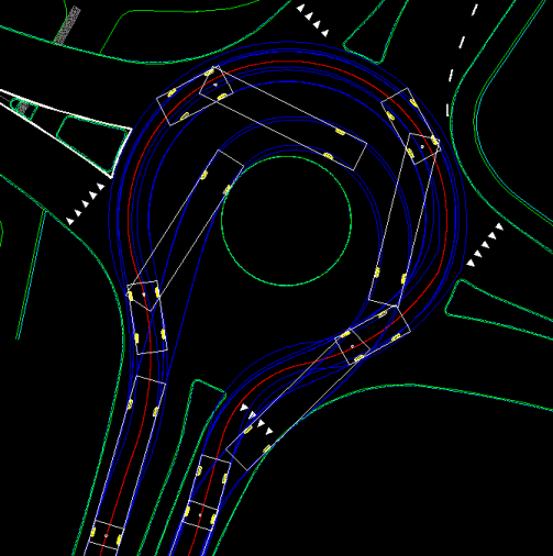
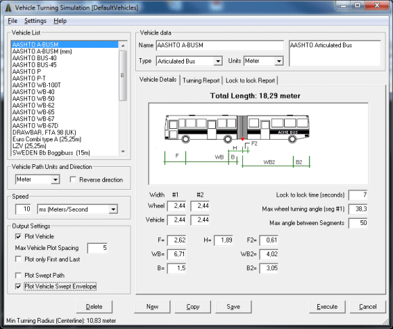
Vehicle Turning Simulation (Vehicle Tracking)
Drafting
Annotate Profiles/Cross sections
|
Vehicle Turning Simulation (Swept path
analysis). Configure vehicles of your own and do analysis in the drawing.
Much faster design than using turning templates.
Create surface cross-sections as 2D or 3D.
Display crossing reference lines
 |
|
| |
Surface Contours

|
|
View Surface slope and direction.
Easily detect
flat areas.
Perimeter of areas with userdefined slopes.
 |
Create
real 3D
cut and fill by applying end-conditions to 3Dpolylines.
Very simple and powerful step by step process.
 |
Create Give Way
 |
Create Chevrons
 |
Limitations:
CadTools does not work with AutoCadLT.
Some features are limited for unregistered users.
Problems running CadTools? Probably it's Vista's
UAC dabbling, try to launch CadTools as an Administrator. Simply find the
shortcut for CadTools, right click on it then in the Compatibility tab select
the option that say: Run this program as an Administrator.
If you are using Bricscad you will find the Vehicle Turning in
BricsTurn. The
Vehicle Turning is also
available as a freeware for Microstation V8.
MSTurn
Downloads
Download (MSI-file,
ca
6,6
Mb),
Last updated
2026-03-27
Build
770
Alternative download (ca
39 Mb
Zip-file containing complete installation and update plus
reference
manual)
Update for CadTools (ca
4,8 Mb),
Last updated
2026-03-27
Build
770
Download update only. If you already installed CadTools and only need the
update, use
this link.
Additional downloads
Reference
Manual English (ca 2,6 Mb) (PDF document, printed documentation
112 pages, updated 2014-06-20)
Reference
Manual Italian (Translated by Gennaro Bellaiuto)
Video Samples (Collection of video
demonstrations)
Default Vehicle
Libraries (metric and imperial), ZIP-file
You may find localized Vehicle Library files in the Vehicle Library section
in CadTools Forum
Extensive Youtube Video Tutorials for CadTools in Spanish by Javi
Lapina, you can translate subtitles to match your needs
Javi Lapina CadTools Tutorial 1
Javi Lapina CadTools Tutorial 2
 CadTools Forum
Online discussion site for
CadTools.
How much
should I donate? There is no right answer to that, the result is always the same
no matter how much or little you donate.
Received donations
are used for paying
Server, Domain and Software fees.
Please note that donation notifications are sent to me from PayPal by email and
I manually send you a registration email as soon as possible.
Generally I respond same day. If you haven't
received
a responding email in a couple of days, check your spam filter or post a message
to me in CadTools forum.
lars.karlsson@glamsen.se
Latest update (202
6-03-27
Build
770)
Fixed bug in "Convert, Polyline to
3D Polylines", removed unwanted point at end of arcs. Added message if
closed objects used arcs as closing element.
Update (2025-04-28
Build
768)
Added support for exporting Leaders to Excel (Lines, Export Leader to
Excel).
Enhanced Polyline Stationing with option to Annotate Vertices Only (Lines,
Stationing).
Update (2025-04-14
Build
767)
Cross Section area calculation. Fixed
unwanted behavior when surface line and proposed does not intersect.
Added setting for display (plot) area figures in drawing.
Update
(2024-10-14
Build
765 and 766)
Older ZWCAD+ could not be detected. Fixed
in Build 766
Update
(2024-07-17
Build
764)
CadTools detects supported
CAD versions into the list in Settings form.
Update
(2024-04-08
Build
763)
Added support for AutoCAD 2025
Update
(2023-11-02
Build
762)
Added support for ZWCAD 2024
Update
(2023-10-31
Build
761)
Fixed bug in Cross Sections, small triangles edges
sometimes was not recognized. This resulted in incorrect cross-section lines (to
short, missing parts near triangle edges.
Update
(2023-06-07
Build
760)
Added support for AutoCAD 2024.
Update
(202
3-03-12
Build
759)
Fixed support for AutoCAD 2023 that didn't work at all.
Update (2023-01-06
Build
758)
Fixed issue in "Join 3DPolyline" using BricsCAD.
Update (2022-10-03
Build
757)
Added support for ZWCAD 2023
Update (2022-10-01
Build
756)
Fixed minor bug in "Draw from Coordinates"
Updated Help File
Changed layout in Settings Dialog
Update (2022-04-28
Build
755)
Fixed bug in Blocks, Match Blocks With Lines (Drainage Network Evaluation)
Update (2022-04-25
Build
754)
Added support for AutoCAD
2023
Update (2022-04-23
Build
753)
Enhancement:
Draw from Coordinates, Right click in Grid for inserting Zero is changed to any
value.
Update (2022-04-08
Build
751)
Bugfix:
Exporting MText to Excel resulted in missing character (last character)
Update (2021-10-30
Build
750)
Bugfix: View
Surface Slope Direction, when using a scale factor arrows pointing in wrong
direction (upwards)
Added: User setting for number of decimal places for contour annotations
(Surface Contours command)
Update (2021-09-12
Build
749)
Option to plot cross-sections in reverse direction.
Update (2021-08-09
Build
748)
Added support for AutoCAD 2022 and BricsCAD.
Update (2021-07-10
Build
747)
Changed behavior of annotation offset parameter in
stationing command, zero offset now put the annotation text (insertion point)
aligned to the alignment.
Update (2021-06-22
Build
746)
Fixed bug while exporting
to SpreadSheet (Lines/Area/Block/volume). This is only when you don't have Excel
installed
Update (202
1-05-31
Build
745)
Added support for AutoCAD 2022
Update (2020-12-11
Build
744)
CadTools internal SpreadSheet
had problems with copying. Copy All worked but not Copy Selected. This is now
fixed.
Update (2020-12-03
Build
743)
The preview window in "Create Longitudinal
Features" didn't show up.
Update (2020-11-
24
Build
742)
Exporting to spreadsheet with setting "Excel is not
installed on this computer" did not showed CadTools internal SpreadSheet.
Update (2020-11-
06
Build
741)
Added support for ZWCAD 2021
Update (2020-10-
27
Build
740)
Fixed a delivery bug in
previous update, I missed to exclude test code.
Update (2020-10-
26
Build
739)
Extended "Draw from Coordinates" with "Multiple
Block insert" type and Layer overrides for type "Text at Point"
Revision History